Major Transit Systems Crippled, NYC Sees Second-Wettest Hour Ever, and More Rain Is on the Way
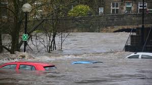
As a slow-moving cold front barrels through the Eastern Seaboard, the Northeast is facing one of the worst flash flood threats in recent memory. With record-breaking rainfall slamming cities from Washington D.C. to New York, New Jersey Governor Phil Murphy has declared a State of Emergency, urging residents to stay off the roads as rescue crews respond to growing numbers of water emergencies.
The FOX Forecast Center issued a Level 3 out of 4 flood risk across parts of the Mid-Atlantic and Northeast, including Philadelphia, Baltimore, and Washington D.C., with forecasters warning the worst may not yet be over.
Record Rainfall and Urban Chaos
NYC Hit With Second-Wettest Hour Ever; Transit Systems Buckle
At the eye of the storm was New York City, which experienced its second-wettest hour on record, registering a staggering 2.07 inches of rainfall between 7 PM and 8 PM, trailing only the remnants of Hurricane Ida. With water pooling faster than storm drains could manage, flooded subway stations, submerged roadways, and suspended transit lines paralyzed much of the metropolitan region.
Commuters faced a nightmare scenario:
-
New York City Subway and Grand Central Metro North reported extreme delays and partial service suspensions.
-
NJ Transit canceled routes as standing water overwhelmed infrastructure.
-
Major airports across the Tri-State Area enforced Ground Stop delays, leaving thousands stranded.
-
Emergency services scrambled to conduct water rescues across New Jersey and New York boroughs.
Governor Murphy’s Urgent Call
“Stay Off the Roads,” Says NJ’s Leader as Flood Threat Escalates
With water levels rising rapidly and flash floods inundating urban and suburban neighborhoods, Governor Phil Murphy declared a State of Emergency, emphasizing that public safety was paramount.
“We’re urging residents to stay home unless absolutely necessary,” Murphy said. “Floodwaters are unpredictable and dangerous. Don’t risk your life or first responders’ lives by testing the roads.”
Murphy’s order activated emergency management protocols, allowing for quicker mobilization of rescue teams and resource distribution to flood-stricken areas.
Flash Flood Forecast: Why This Storm Is So Dangerous
Stalling Front + Near-Record Moisture = Catastrophic Potential
Meteorologists warned that the combination of a stalling front and atmospheric moisture at near-record levels is a recipe for disaster. Storms are developing and stalling over the same areas, producing rain rates of 3 inches per hour or more.
The most impacted zones stretch from eastern Pennsylvania to North Carolina, but urban centers along the I-95 Corridor are at the heart of the emergency. Flash floods are particularly dangerous due to:
-
Saturated soil from recent rains, making the ground incapable of absorbing more water.
-
Urban development, which reduces natural drainage and increases flood runoff.
-
Storm clustering, with multiple cells dumping rain on the same location for hours.
Infrastructure Under Pressure
Subways, Power Grids, Airports Face Cascading Impact
Beyond transportation chaos, other systems are straining under pressure. With waterlogged roads and flooded buildings:
-
Power outages are being reported in low-lying neighborhoods.
-
Emergency stormwater systems are overwhelmed in parts of New Jersey and New York.
-
Public health concerns are rising with untreated water entering public systems.
Justin Atkin, a port infrastructure analyst, compared the instant disruption from the storm to recent trade shocks like Trump’s tariffs or Red Sea shipping diversions, emphasizing how fragile the Northeast’s infrastructure has become under pressure.
More Rain on the Horizon
Tuesday and Wednesday Bring Scattered Relief—But Not for Long
According to the FOX Forecast Center, rain will become more scattered on Tuesday and Wednesday, offering brief relief to beleaguered cities. However, the skies will remain overcast and humid, keeping recovery efforts sluggish.
Worse yet, another system is forming in the Midwest and is expected to crash into the East by Thursday, potentially extending the flood threat through the weekend. With many areas already at or near saturation, any additional rainfall could push communities past the tipping point.
By Saturday, the region may see a brief drying period—but forecasters caution it may not last long as the East remains trapped in a persistent wet-weather cycle.
Economic Impact Looms
Delays, Infrastructure Damage, and Disrupted Supply Chains
The storm isn’t just a weather event—it’s an economic shock. Early indicators suggest:
-
Commercial shipments delayed as freight terminals and port routes face access issues.
-
Real estate damage claims are expected to surge from flooded homes and businesses.
-
Retail disruptions as stores remain closed and deliveries stall.
-
Insurance firms bracing for significant claims from auto, home, and transit customers.
Economists warn that if the pattern continues into next week, the cumulative economic losses could exceed $1 billion for the region—especially when compounded by potential additional rain later in the month.
Conclusion: More Than Just a Storm
Climate, Infrastructure, and Policy Collide in Northeast Flash Flood Disaster
Monday’s deluge is more than a headline—it’s a warning. As climate volatility increases, cities like New York, Philadelphia, and Washington D.C. are repeatedly reminded of their infrastructure’s vulnerability. From storm drains to subway tunnels, the systems designed for a 20th-century weather model are now buckling under the realities of 21st-century climate pressure.
And with federal and state disaster declarations likely, the storm will leave behind more than just puddles. It will spark conversations about resilience funding, green infrastructure investments, and the long-overdue need to modernize America’s aging urban cores.